33082: GIL NA MUILNE, KNEEP, LEWIS – BLACK HOUSE (Undated)
Summary:
BLACK HOUSE (Undated)
Blackhouse and enclosure
Location:
NB 09694 36034
Full description:
NB03NE 51.01 0968 3602
Formerly NB03NE 38
A single T-shaped building is depicted on the 1st edition of the OS 6-inch map (Island of Lewis, Ross-shire 1853, sheet 12). One unroofed building is show on the current edition of the OS 1:10000 map (1974).
Information from RCAHMS (AKK) 18 September 1997.
no.50
This is a post-medieval blackhouse with two associated enclosures forming the northernmost of the blackhouse settlements on the Berie foothills (with the exception of the uniquely located site at Liongol which overlooks both Tragh na Berie and Traigh Cnip). The walls of the main structures are of drystone with a turf/earth core. In places a massive boulder foundation course is visible. The walls are generally up to 1.5m wide and survive to 2m in height. The internal corners of this structure were rounded. The western part of the structure has been cut into the hillside. The structures have externally rounded corners.
The surviving structure began as a single blackhouse 16m by 6m in external dimensions. It had opposing centranl entrances c. 1m wide in the north and south walls. A stone platform projects from the western end of the structure. This may relate to an earlier structure or to a massive foundation for the blackhouse.
A secondary, smaller blackhouse was subsequently built on to the north side of the original structure, opening off the latter’s north entrance. This was of similar construction to the primary structure, running parallel to it, with internal dimensions of 10m by 3m and a wall 2m wide. It s south wall was formed by the original sturcutre. This sturcutre had an entrance in the north-west corner of the north wall. The internal corners of this structure were markedly more square than the earlier blackhouse. The internal area of this secondary structure, and the west end of the primary structure have filled with nettles as opposed to the grass cover inside the eastern end of the primary structure.
Subsequent partition walls have been added to both structures. The primary blackhouse has been divided into two rooms at the entrance area. The secondary structure has been walled off near its entrance to create a much smaller internal area accessible from its entrance. The connecting entrance between the two structures has also been blocked.
The side is indicated as unoccupied on the 1st edition Ordnance Survey map surveyed in 1850 but as occupied on the 2nd edition, where it is also indicated as a simple rectilinear structure. The implication is that the site underwent an abandonment of uncertain duration including the period around 1850, but was reoccupied prior to 1895.
Armit 1992, 64
References:
Ian Armit. 1992. CFA, University of Edinburgh Archaeological Field Survey of the Bhaltos (Valtos) Peninsula, Lewis.
1994. ‘Archaeological field survey of the Bhaltos (Valtos) peninsula, Lewis’, Proc Soc Antiq Scot. Part No 124. No.50, 87, 88
Acknowledgement:
Information provided by Western Isles Council Sites & Monuments Record, January 2006.
Record Location
Details
- Record Type:
- Historical or Archaeological Site
- Type Of Site:
- Black House
- SMRRecord ID:
- MWE72743
- Record Maintained by:
- CEU
Related Media
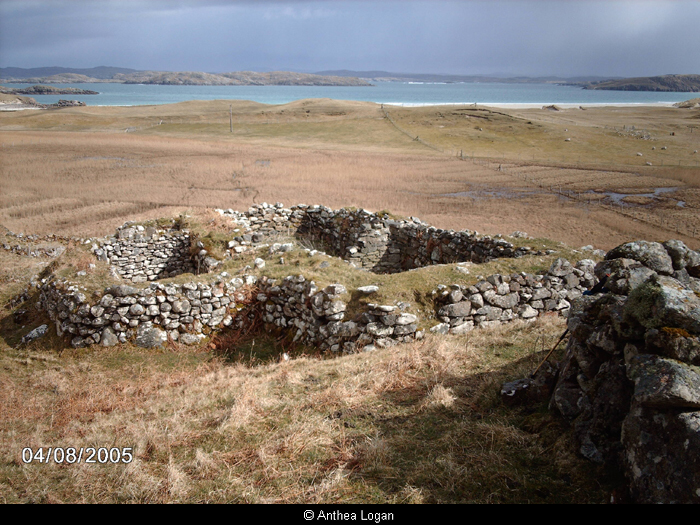
Blackhouse, Gil na Muilne
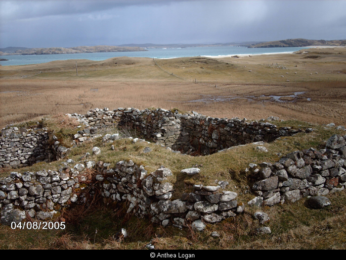
Blackhouse, Gil na Muilne