31589: LSFH 26.3 Rubha nan Carn – BLACKHOUSE; LONGHOUSE
Summary:
HOUSE (Crofting – 1850 AD to 1950 AD)
BLACK HOUSE (Crofting – 1850 AD to 1950 AD)
COW HOUSE (Crofting – 1850 AD to 1950 AD)
LONGHOUSE (Crofting – 1850 AD to 1950 AD)
Blackhouse
Location:
NB 28414 16477
Full description:
"Situated on a prominent knoll above the north shore of Loch Seaforth Head this monumentally sized blackhouse measures 25 x 7 metres and is orientated from south-east to north-west. Showing extensive signs of greying (introduction of white features including chimney flues etc.) this structure is primarily constructed of stone faced, earth cored walls, though the south-eastern gable is constructed on stone bonded with mortar. This gable is a later insertion, and though it has no window (a feature often seen in grey improvements) it does have a hearth and flue, with a chimney stack that still survives to its original height of over 3 metres. Internally the house has two partitions. The first, 6 metres from the south-east (dwelling) end, is clearly butted onto the western outer wall of the structure and is also constructed of stone and mortar. This partition also has a hearth and flue but as it now only stands to 1.4 metres it is not clear whether it used to have a full chimney breast or whether the flue stopped at the wall head and issued into the roof space. The second partition, 12 metres from the building’s south-east (dwelling) end, is constructed of stone and is also butted onto the western external wall. The purpose of this partition is unclear, but it would seem perhaps that it was designed to provide additional dwelling space, shortening the area used at the north-west end of the building as a byre. This then allowed the house to follow the classic pattern for spacial usage in a late crofting blackhouse (as partially displayed in the Arnol reconstruction) with the dwelling having two chambers, a ‘living area’ and a ‘bedroom’. The byre end of the structure (north-west) is apsoidal in form, constructed of larger stones and boulders, and standing to over 2 metres in height presents a monumental faade. At some point this structure seems to have failed, presumably under the weight of the roof structure (now missing). As is often the case, rather than rebuild the original wall, a secondary wall has been built across the width of the house, immediately within the north-western end. This new wall is likely to have formed the sprining point for the north-west end of a modified and shortened roof. This later modification is located 19 metres from the south-east (dwelling) end of the house. Two entrances are visible, one blocked and the other open. The open entrance is opposite the most northerly partition, 13 metres from the south-east end of the building in the eastern wall. This entrance would allow access directly either to the dwelling or byre areas. The second (blocked) entrance is 17.5 metres from the south-east end of the building, only 4 metres from the open entrance and also in the eastern wall. This represents an earlier phase of usage of the structure where access was primarily through the byre. Such access arrangements are typical for early, pre-crofting blackhouses, and in this case help in the understanding of the structure. The location of this blocked entrance, and an examination of the external walls suggests that the structure has been extended to the south-east, possibly when the gable was inserted, or alternatively in two stages, with the gable being inserted during the second expansion. As the blocked doorway tends to suggest an early antecedance for the structure it is reasonable to suggest that in a pre-crofting period a house of smaller proportions (perhaps 10-12 metres long) stood on the same site. The prominent location and monumental size of this structure have always been taken to point to it being related to the location of the MacKenzie Seaforth castle, that is supposed to have been constructed in the vicinity around 1610. Small trial excavations that were carried out prior to the construction of the current barn (to the west) failed to identify and remains that might indicate the presence of lordly residence at that date. Locally it is argued that this site is in fact not the location of the MacKenzie Seaforth castle, which is said to have been positioned 1000 metres to the west on the headland known as Ard Sithaig. There is no sign of a separate barn structure relating to this house, though there are a number of smaller house structures to the south (45.2, 45.3) that may have been used as a barn." (Burgess 2004 57-59)
References:
Chris Burgess, Northamptonshire Archaeology. 2004. Northamptonshire Archaeology Archaeological Survey and Evaluation of Eilean Chalium Chille and the Putative Site of the Seaforth Head Castle. Part No Loch Seaforth Head Gazeteer.
Acknowledgement:
Information provided by Western Isles Council Sites & Monuments Record, January 2006.
Record Location
Details
- Record Type:
- Historical or Archaeological Site
- Type Of Site:
- House; Black House; Cow House; Longhouse
- Period:
- Crofting (1850-1950 AD); Post-Medieval (1540-1900 AD)
- SMRRecord ID:
- MWE144632
- Record Maintained by:
- CECL
Related Media
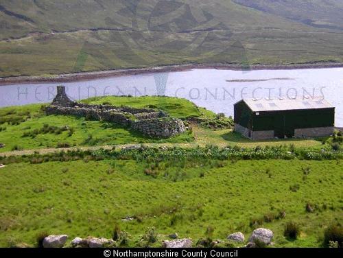
Blackhouse at Loch Seaforth Head