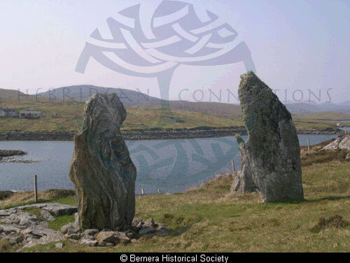
31340: ‘TURSACHAN’, BARRAGLOM, GREAT BERNERA – STONE CIRCLE (Neolithic – 4000 BC to 2351 BC)
Summary:
STONE CIRCLE (Neolithic – 4000 BC to 2351 BC)
Stone circle
Location:
NB 16422 34266
Full description:
NB13SE 2 1642 3424.
(NB 1642 3424) Tursachan (NR). (Supposed Druidical Remains).
OS 25" map, 1897.
Three standing stones and a prostrate pillar stone occupying a very unusual position on a steep rocky slope ending in a cliff.
While the erect slabs form the northern arc of a circle, they are placed with their broad faces looking towards the water. The most westerly stone, which stands 61’6" from the most easterly stone measures 7’6" in height, 4′ in width and 19" in thickness, while the latter, which is the smallest of the group, and is placed within 12′ of the cliff edge, is 3′ high, 4′ broad and from 2" to 10" thick. The most southerly (northerly) stone, which stands 33’11" distant from the first stone and from the second, measures 9’1" in height, 3’6" in breadth and 13" in thickness, and the prostrate stone, which lies 9’2" distant between it and the smallest slab, is 8’3" long, 3’9" broad and 1’5" thick.
RCAHMS 1928, visited 1914; B Somerville 1912.
Three standing stones and one prostrate stone, as described by the RCAHMS and illustrated by Somerville. As all the stones face S, it cannot be assumed that this is a stone circle. Name ‘Tursachan’ still known locally.
Visited by OS (NKB) 22 June 1969.
Investigation in 1989 confirmed that the cobbled surface extended S to a built up retaining wall, itself built on bedrock at the top of a cliff. Two elongated stones, 1m and 1.6m long, were originally set upright on top of the cobbled platform. In antiquity most of the packing stones had been dismantled and set aside on the cobbles and the two erect stones dismantled.
The precise positions and orientations of the latter were determined, 0.8m apart, and some packing stones and a padstone under the larger stone were found in situ. These were reset in concrete and the two elongated stones re-erected.
The packing stones that had been set aside were also reincorporated in the structure, with concrete, but their exact positions remain conjectural due to the prehistoric dismantling and due to damage by an adjacent water pipe trench.
Sponsors: Comte de la Lanne Mirrlees; SDD HBM.
G Curtis and M Curtis 1989b.
Further investigation was undertaken in 1990 to establish relative stratigraphy of built-up platform areas. Another prone stone, erected and dismantled in antiquity, was confirmed.
Sponsors: Comte de la Lanne Mirlees, HBM.
G R Curtis and M R Curtis 1990b.
‘The monument…comprises a prehistoric setting of standing stones, some of which have recently been re-erected. The area to be scheduled is approximately semi-circular on plan and 60m in diameter, bounded on the S by Loch Roag, to include the stone setting and an area around it in which evidence relating to its construction and use may survive.’
HS Scheduling Document 22 January 1993.
References:
The standing stones of Callanish, Publisher: {s.n.} (Essoprint), The Standing Stones of Callanish. 30
Megalithic science: ancient mathematics and astronomy in north-west Europe, Publisher: Thames and Hudson, Megalithic Science: ancient mathematics and astronomy in north-west Europe. 119
Megalithic sites in Britain, Publisher: Clarendon Press, Megalithic Sites in Britain. 126, 128, 138
The stones around Callanish: a guide to the minor megalithic sites of the Callanish area, Publisher: G and M Ponting, The Stones around Callanish: a guide to the minor megalithic sites of the Callanish area. 27-8
1903-4. ‘Notes on certain structures of archaic type in the Island of Lewis – beehive houses, duns and stone circles’, Proc Soc Antiq Scot. Part No 38. 189-90
1912. ‘Prehistoric monuments in the Outer Hebrides, and their astronomical significance’, J Roy Anthrop Inst. Part No 42. 43-6 No. II.4
RCAHMCS. 1928. The Royal Commission on the Ancient and Historical Monuments and Constructions of Scotland. Ninth report with inventory of monuments and constructions in the Outer Hebrides, Skye and the Small Isles, Publisher: HMSO The RCAHMS 9th Report and Inventory: Outer Hebrides, Skye and the Small Isles. 24, No. 86 fig. 34
1976. ‘Callanish’, Discovery and Excavation, Scotland. Callanish VIII: Bernera Bridge, 57
1985. ‘Bernera Bridge (Uig parish) standing stones’, Discovery and Excavation, Scotland. 64
1987. ‘Bernera Bridge (Uig parish) standing stone’, Discovery and Excavation, Scotland. 61
1988. ‘Bernera Bridge (Uig parish) standing stones’, Discovery and Excavation, Scotland. 32
1989. ‘Bernera Bridge (Uig parish), standing stones’, Discovery and Excavation, Scotland. 72
1990. ‘Bernera Bridge (Uig parish), standing stones (Callanish site VIII)’, Discovery and Excavation, Scotland. 49
Acknowledgement:
Information provided by Western Isles Council Sites & Monuments Record, January 2006.
Record Location
Details
- Record Type:
- Historical or Archaeological Site
- Type Of Site:
- Stone Circle
- Period:
- Neolithic (4000-2350 BC)
- SMRRecord ID:
- MWE4112
- Record Maintained by:
- CEBL
